DGPS
Entity attached to:
Platform
Main activity
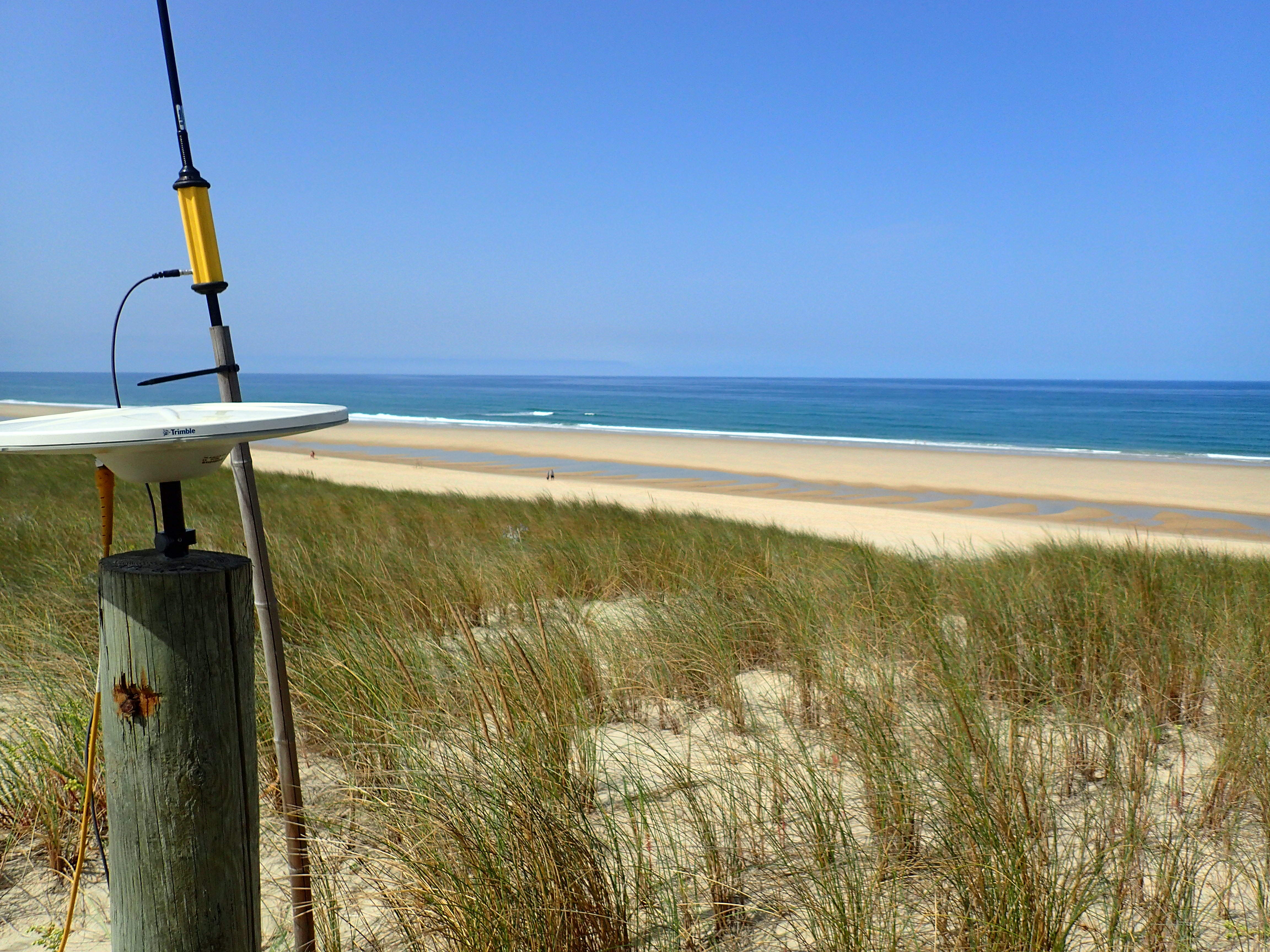
Morphology - DGPS is an improved version of GPS which allows horizontal and vertical positioning with sub-decimetric precision.
This set of equipment is the property of the operating structures and not of the DYNALIT Network.
The postal address indicated is that of the ILICO coordination (CNRS / Ifremer). The networks are distributed throughout metropolitan France and overseas. The contacts indicated are those of local referents.
Description
Description
Category
Land-based tests and test sites for engineering and ocean observation
Analyses, measurements and metrology
Observation
Digital
Modelling and in situ data providers
In situ tests and experimentation
Coastal
Littoral
Analyses, measurements and metrology
Observation
Digital
Modelling and in situ data providers
In situ tests and experimentation
Coastal
Littoral
hasafcfaf18-c675-48af-beca-8bb1ff090072
Scientific disciplines
Marine geosciences / Geology / Sedimentology / Seismology
Mechanics
Microbiology
Bathymetry
Hydrology / Hydrography
Biological oceanography
Physical oceanography
Digital modelling
Marine environment
Ecosystems
Meteorology
Mechanics
Microbiology
Bathymetry
Hydrology / Hydrography
Biological oceanography
Physical oceanography
Digital modelling
Marine environment
Ecosystems
Meteorology
Strategic areas of action
Environmental and coastal planning and development
Examples of work
Journal of Coastal Research, VOL. 88, NO. sp1, December 2028
Type of entity
Equipment
Keywords
Geomatics, Coastal geomorphology, Geophysics, Hydrodynamics, Hydrology, Meteorology, Sedimentology, Remote sensing, Climate, Public policies, Natural risk management strategy, Climatology
Website
Modification date: 09/04/2025 01:28:42
For details of the service, see the related platform or infrastructure
A pioneer in ocean science, IFREMER's cutting-edge research is grounded in sustainable development and open science.His vision is to advance science, expertise and innovation to protect and restore the ocean, sustainably use marine resources to benefit societ, create and share ocean data, information & knowledge.
With more than 1,500 personnel spread along the French coastline in more than 20 sites, the institute explores the 3 great oceans: the Indian, Atlantic and Pacific oceans.
Founded in 1984, IFREMER is a French public organization and its budget approximates 240 million euros. It is operating under the joint authority of the French Ministry for Higher Education, Research and Innovation, the French Ministry for the Ecological and Solidary Transition, and the French Ministry of Agriculture and Food.
The National Center for Scientific Research
The French seashore and coastal research infrastructure ILICO (Infrastructure de Recherche Littorale et Côtière) was established in 2016 with the support of Ministry of Higher Education, Research and Innovation. ILICO is a notable example of national infrastructure and interinstitutional efforts to observe and understand coastal and ocean environments and ecosystems as a whole. ILICO brings together observation mechanisms involving the collection of samples and the deployment of various measuring instruments. Long-term monitoring allows for the understanding and prediction of large-scale coastal processes and phenomena which can impact on coastal and littoral zones (for example quantifying the impact of specific extreme or intermittent events such as tsunamis or cyclones).
This research infrastructure aims to:
- Ensure that observations in littoral and coastal environments respond to issues in society and associated scientific questions,
- Gather and coordinate a multidisciplinary network of observatories for littoral and coastal environments,
- Guarantee the interoperability and quality of observations conducted under different observation systems.
ILICO brings together physical, biogeochemical and biological observation networks (known as elementary networks). In 2018 there are 8 of these:
1. Coastlines and coastal morphological dynamics (DYNALIT)
2. Seawater level (SONEL)
3. Mediterranean Ocean Observing System for the Environment (MOOSE)
4. Physicochemical developments in coastal waters (SOMLIT)
5. Developments in tropical coral ecosystems (CORAIL)
6. Insular Pacific Coastal Waters Network (REEFTEMPS)
7. High-frequency physical and chemical parameters (COAST HF)
8. Microphytoplankton (PHYTOBS)
ILICO is jointly coordinated by CNRS and Ifremer, other bodies involved in its governance are the network of marine universities, IRD, SHOM, IGN, CEREMA, and BRGM.
The data collected through ILICO networks will be integrated in a dedicated ocean database portal called ODATIS.
Some components of ILICO are part of the H2020 project JERICO-NEXT, which helps harmonise research infrastructures for coastal observations in Europe.
-> What is an elementary network? Derived from the own terminology of the research infrastructure, the term ?elementary network? designates a national observation service labeled, or in the process of being labeled, whose observations relate to coastal and / or coastal environments and which has been integrated at ILICO.
Adress
Place Copernic
Address line 2
IUEM et Ifremer, site du Technopôle Brest-Iroise
Zip code/Postcode
29280
Town/city
PLOUZANÉ