Marine WMS Server
Main activity
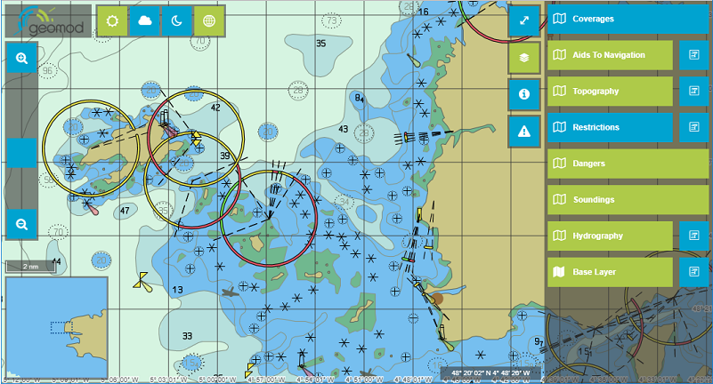
This server allows to display, in your web browser, Cartographic information from Electronic Navigational Charts (ENC) in the form of S52 standardized geo-referenced images (GETMAP) and image requests (GetFeatureInfo).
Description
Certification, standardization, calibration
Category
Software
Digital
Spatial data providers
Digital
Spatial data providers
hasafcfaf18-c675-48af-beca-8bb1ff090072
Scientific disciplines
Marine Engineering
Marine geomatics / Habitat mapping
Marine geomatics / Habitat mapping
Strategic areas of action
Environmental and coastal planning and development
Marine biological resources
Maritime safety and security
Maritime ports, infrastructure and transport
Shipbuilding and leisure boatbuilding
Marine biological resources
Maritime safety and security
Maritime ports, infrastructure and transport
Shipbuilding and leisure boatbuilding
Examples of work
Type of entity
Equipment
Keywords
WMS, Electronic Navigational Chart, Nautical Chart, ENC
Modification date: 09/04/2025 01:26:07
Nautical chart web services
Concerned publics
Companies
Research partners
Other researchers
All
Institutions
Others
Research partners
Other researchers
All
Institutions
Others
Terms of access
Research collaboration access
Full service access
Full service access
Movable ?
yes
no
Interoperability between marine data users
Concerned publics
Companies
Research partners
Other researchers
All
Institutions
Others
Research partners
Other researchers
All
Institutions
Others
Terms of access
Research collaboration access
Full service access
Full service access
Movable ?
yes
no
Geomod is a software developer and distributor for terrestrial and marine geomatics. We are also distributor of software in the field of water modelling.
All these software are essentially scientific applications with high added value. In particular, we collaborate with the CSTB for the last fifteen years on the development of the MithraSUITE software suite.
Since the creation of the company, we work with Innovyze (formerly Wallingford Software) in the field of water modelling, being the official French distributor.
Since 1999, we collaborate with Cadcorp in the geomatic sector, being ?Cadcorp Partner? and their french distributor.
Since 2008, we are also PRIMAR distributor for all Electronic Navigation Charts.
We also provide services (specific developments, training and support) in these different fields of geomatics and hydro.
Adress
41 Rue du Château
Address line 2
Immeuble Galaxie
Zip code/Postcode
29200
Town/city
BREST