PortSide - S57 navigational chart production
Main activity
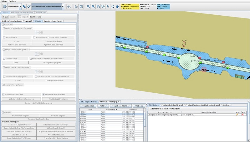
PortSide allows to create and edit datasets in S57 format: Electronic Navigational Charts for marine, harbour or river (ENC, IENC), as well as AML vector layers. For example, PortSide is the perfect tool for the harbour hydrographic service wishing to create its own harbour charts, more accurate than the official charts and containing the objects of interest to the harbour pilots. Developed in java, it results from Geomod?s strong expertise in hydrographic data exploitation and in IHO/IMO standards: S57, S52, S63, S68, etc.
Description
Certification, standardization, calibration
Category
Software
Digital
Digital
hasafcfaf18-c675-48af-beca-8bb1ff090072
Scientific disciplines
Marine Engineering
Marine geomatics / Habitat mapping
Marine geomatics / Habitat mapping
Strategic areas of action
Marine energy and mining resources
Environmental and coastal planning and development
Marine biological resources
Maritime safety and security
Maritime ports, infrastructure and transport
Shipbuilding and leisure boatbuilding
Environmental and coastal planning and development
Marine biological resources
Maritime safety and security
Maritime ports, infrastructure and transport
Shipbuilding and leisure boatbuilding
Examples of work
Type of entity
Equipment
Keywords
Electronic navigational chart, S57, ENC
Modification date: 09/04/2025 01:26:14
Concerned publics
Companies
Other researchers
All
Institutions
Others
Other researchers
All
Institutions
Others
Terms of access
Full service access
Movable ?
yes
no
S57 chart creation
Concerned publics
Companies
Research partners
Other researchers
All
Institutions
Others
Research partners
Other researchers
All
Institutions
Others
Terms of access
Research collaboration access
Full service access
Full service access
Movable ?
yes
no
Software and S57 standard training
Concerned publics
Companies
Research partners
Other researchers
All
Institutions
Others
Research partners
Other researchers
All
Institutions
Others
Terms of access
Full service access
Movable ?
yes
no
Description
We offer S57 and PortSide training session wherever you need
Geomod is a software developer and distributor for terrestrial and marine geomatics. We are also distributor of software in the field of water modelling.
All these software are essentially scientific applications with high added value. In particular, we collaborate with the CSTB for the last fifteen years on the development of the MithraSUITE software suite.
Since the creation of the company, we work with Innovyze (formerly Wallingford Software) in the field of water modelling, being the official French distributor.
Since 1999, we collaborate with Cadcorp in the geomatic sector, being ?Cadcorp Partner? and their french distributor.
Since 2008, we are also PRIMAR distributor for all Electronic Navigation Charts.
We also provide services (specific developments, training and support) in these different fields of geomatics and hydro.
Adress
41 Rue du Château
Address line 2
Immeuble Galaxie
Zip code/Postcode
29200
Town/city
BREST